Tytoona Cave Preserve, located in limestone-rich Sinking Valley, Blair County, Pennsylvania, is the tenth cave property of the National Speleological Society. The Western Pennsylvania Conservancy sold the 6.8 acres to the NSS in December 23, 1997. Tytoona Cave is primarily used for recreational and educational purposes today. It is one of the most significant caves in the commonwealth of Pennsylvania.
Although several other caves exist in Sinking Valley, only Tytoona and the Arch Spring are of much interest. Arch Spring gave its name to a village that hardly exists today. The arch at Arch Spring resembles the famous Natural Bridge in Virginia, but is much smaller. The limestone arch is 40 to 50 feet high, and the opening is 15 to 20 feet in diameter, with Sinking Run flowing through it. Arch Spring, the source of this part of Sinking Run, is the eighth largest spring in the state, discharging from 2000 to an estimated maximum of 30,000 gallons per minute. Upstream from the arch is a small pond in a large, steep-sided sinkhole. This is said to be a remnant of a large room that collapsed thousands of years ago. The sink is a least 100 feet long, 50 feet wide, and perhaps more than 30 feet deep. At the far side is an opening about 4 feet in diameter. This is Arch Spring, the resurgence of Tytoona Cave, over 4000 feet away in a straight line. The Arch Spring end of the system has nothing to offer the dry caver, but it is a challenge for cave divers, although it is privately owned and diving is not currently allowed. It has many large submerged rooms, one of which was described as being over 100 feet deep.
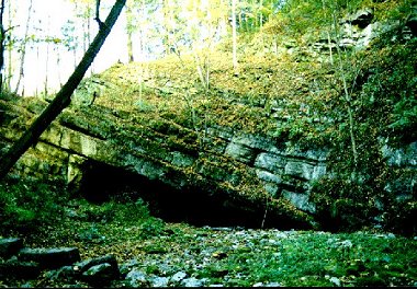
The entrance to Tytoona Cave is about a mile away from Arch Spring by road. It is in a large collapsed sink, another remnant of a large room, that is visable from the road during most of the year. The Tytoona Management Committee has improved the property with safer parking and a graveled trail. There are several signs and a kiosk display. The display and brochures educate the public about the caving, the NSS, the property, and preserve policies.
The stream appears from under the far wall of the sink and flows for a short distance before entering the cave. The size of the stream fluctuates greatly. Sometimes it is even dry on the surface, but in the wet season it is about 25 feet across and 2 to 3 feet deep. In spring, it can be a raging torrent.
DESCRIPTION
 The roof of the entrance slopes with the 15-degree dip of the massive beds of the Trenton Limestone and is about 40 feet wide and up to 12 feet high. The trunk passage from the entrance to the sump averages about 25 feet high and 30 feet wide, with gentle bends. The floor is fairly level, execpt for the clay banks along the stream, which occupy most of the passage width in places. There are some deep pools toward the back. Visitors can walk on clay paths, badly eroded remnants of a commercial trail, to avoid the stream. About halfway to the visitors' register, a climb up a clay bank leads to a small room filled with Pennsylvania cave mud, one of the few passages in the cave. Farther on, old cut steps lead up another clay bank to the Balcony, from which one can look down and view much of the cave passage. The ledge contains a path that leads to the register, cemented to the wall where the ledge is briefly enclosed, blocking the view of the main passage. Beyond the register, the path leads back down to the stream passage. Here a flowstone-choked chimney can be seen, as well as other speleothems hanging above the stream. Up to this point, 400 feet in, the cave is easy for almost anyone. However, the novice may think that the cave ends here, since before him will be water and a pile of logs that seem to reach the ceiling. Those familiar with the cave and the proper route can bypass the Log Jam and enter another 500 feet passage. In this part of the cave, unwary visitors can end up in deep water, and wading, at least, is required. Beyond the wettest part, you can leave the stream, which meanders on between clay banks. The passage stays about the same size, and occasional wooden remnants of the early attempt at commercialization can still be found, half buried in mud. At one point, a large flowstone overhangs the passage where it was deposited on a bank that has since been eroded away. Beyond that and across the stream is an area of quite nice formations, although some of them have been vandalized. Finally, about 900 feet from the entrance, the first sump is encountered. Note: Diving is now prohibited without special permission from the cave-preserve manager.
With permission from previous owners, cave divers were able to find much more cave. The room beyond the first sump contains world-class formations. Thanks to Mother Nature, this room is protected by the sump. There are additional sumps and large water-filled rooms, and eventually the passage comes close to connecting to the Arch Spring Cave, but an underwater breakdown blockage has prevented a through-trip. Dye-tracing has confirmed the stream connection.
Few bats have never been seen in Tytoona cave, but it is not unusual to see crayfish and other aquatic animals. Large cave salamanders have been seen deep in the cave. Occasionally a dead muskrat is found when floodwaters recede, and snakes and frogs are sometimes seen.
Most of the easy part of Tytoona Cave is largely devoid of formations, perhaps due to the floods, which together with its distance from major highways, account for the failure of past attempts at commercialization. The standard figure of 3,740 feet of Tytoona's length does not take into account the whole system, which would be closer to a mile from end to end.
HISTORY
White men first came to Sinking Valley area in the early 1750's. One piece of folklore has Bedford Rangers chasing Indians who had killed two settlers into Tytoona Cave. The Indians never emerged from the cave, and it is said that they either died in the cave or escaped by another entrance. As no other entrance has ever been found, it is likely that the rangers, afraid to enter the cave, just did not wait very long.
The first published account of the area appeared in an article by Emollit Mores in the Columbian Magazine in 1788. The valley, then on the frontier of Bedford County (now in Blair County), was referred to as Sinking Spring Valley or Bald Eagle Valley. There was some mining of valuable lead and zinc ores, and the heavily forested valley was home of perhaps forty families, protected from Indian raids by Fort Roberdeau. While not all Indians were hostile, few were trusted. The fort was eventually abandoned, because no large ore veins were found. Iron ore was more abundant, but could be found in much safer parts of Pennsylvania. A stone building with firing slots, built by the Isett family before 1795, can still be seen on the Arch Springs property.
The Columbian mentions the spring, where "a rude arch of stone hanging over it, forms a passage for the water, which it throws out with some degree of violence, and in such plenty as to form a fine stream, which at length buries itself again in the bowels of the earth." It also alleged pits nearly 300 feet deep along a subterranean stream in rapid motion. The stream descends from rocky hills to enter the mouth of a large cave. "This opening in the hill continues about four hundred yards when the cave widens, after you have got round a sudden turn, which prevents its being discovered till you are within it, to a spacious room, at the bottom of which is a vortex, the water that falls into the whirling round with amazing force; sticks, or even pieces of timber, are immediately absorbed".
The Pictorial Sketch Book of Pennsylvania by Eli Bowen, published in 1852, mentions the arch and cave, summarizing the material from the Columbian with many of the same words. An 1856 book, History of the Settlement of the Juniata Valley, claims that Indians might have shown lead ore from Sinking Valley to the French as early as 1750. It says that settlers took up residence there in 1763. Another account, written sometime in the 1800s, lists Arch Spring as one of the wonders of Sinking Valley. It goes on to say that the village there had three churches and a seminary for young ladies. The population was 263. It also mentions the arch and cave, but again the descriptions are remarkably like those in the earlier article in the Columbian Magazine.
In his 1853 book History of the Valley, U. L. Jones wrote, "Arch Spring and the cave in Sinking Valley are probably among the greatest curiosities to be found in any county. The spring gushes from an opening arched by nature, in such force as to drive a mill, and then sinks into the earth again. The subterranean passages of the water can be traced for some distance by pits or openings, when it again emerges, runs along the surface amoung rocky hills, until it enters a large cave, having the appearence of an immense tunnel. The cave has been explored as far as it will permit, some four hundred feet... where there is a large room, and where the water falls into a chasm or vortex." He appears to have thought that the arch is upstream from the cave.
The arch and cave were clearly shown on a map of Tyrone Township from the 1877 atlas of Huntingdon and Blair Counties. Franklin Platt's 1881 Geology of Blair County gives a short account. "A small stream flows east for a mile and quarter, and then sinks into a large cave. From the cave to Arch Springs, a distance of 4200 feet, there is no surface flow of water, as it all flows through the cave."
Over the years, Tytoona Cave has also been called Arch Spring Cave (inviting confusion with the cave behind Arch Spring itself), Sinking Valley Cave, and, during a commercialization attempt, Indian River Caverns.
Most of the village of Arch Spring has disappeared. A large limestone house bearing a marker with the names of Jacob Isett and his wife Eleanor and the date 1805 still stands next to the spring, and an earlier Isett house built in 1799 and later used as a post office. Both buildings have been restored by the present owner and are in use as a bed and breakfast.
At the beginning of the twentieth century, Robert Morrow, related to the present Dr. Morrow who owns the spring, bought the cave property on June 17, 1901. On March 12, 1918, the property was sold to Henry Ruldolph Bush. Within six months, on September 11, 1918, the property was sold again. James B. Irvin paid $4000 for the 120 acres. On March 26, 1920, Kent M. Irvin bought it for $5500. It is unusal that the property changed hands so often during the period, when families often stayed in one location for generations.
Ralph Stone, in Pennsylvania Caves, describes his 1924 visit to the Arch Spring and Sinking Valley Cave. "The writer found between the forks in the road above Arch Spring, three sinkholes, two of them conical with nearly vertical walls, and the third irregular in shape.... All three of these have pools in the bottom which I believe are the course of Sinking Run, here flowing deep below the surface. Just above the forks of the road is another sinkhole, or a steep short rocky ravine in which a stream emerges from the upper side of a cavity which is wholly occupied by water, and after flowing 75 feet in the open disappears in the entrance to a cave." After some description of the cave, he continues, "The next appearance of Sinking Run is just above Arch Spring where there is a steep-sided hole about 100 feet long, 50 feet wide, and 30 feet deep with a pool in the bottom. The stream which makes the pool passes out through an arch 12 to 15 feet in diameter, through a limestone ledge about 20 feet thick. This is the arch which gaves the place its name."
The rapid turnover of the property ended after Myrtle L. Kiser bought it on April 3, 1930, for $7,100. Possibly the Kiser family had the cave in mind when they bought the property. In July 1947, the cave was opened for tours. It was given the odd name of Tytoona Cave, combining the names of two nearby towns, Tyrone and Altoona. Steps had been constructed down into the sinkhole, and a neat path led tourists back to what is now known as the Log Jam. It's said that there was a ticket booth up by the road and a small resurgence at the other end of the sink. While the period after the end of the Second World War (WWII) might have seemed like a good time to enter the tourist business, things did not go well. The cave lacked formations and floods ruined the clay walkways, and the operation was short-lived.
On May 7, 1965, Art Kiser, Myrtle's son, purchased the property for one dollar. Around 1970, he made plans to reopen the show cave business. Much work was done rebuilding steps, railings, and paths. Electric lighting was put in. He even planned to dynamite into the room that had by then been found beyond the sump, but decided against it when he learned that this might destroy the formations. The cave was to be opened to the public in July 1972 under the new name Indian River Caverns. Then tragedy struck. In June, Pennsylvania suffered one of the worst floods in its history. More than 10 inches of rain fell in three days on already saturated ground and put many towns under water. The Hurricane Agnes flood also completely filled Tytoona Cave, and all of Art Kiser's work was destroyed. Logs washed in then make up much of the Log Jam that is still present today. Kiser still spoke of his dream of reopening the cave, but he never did.
MODERN EXPLORATION
A map of the then-known parts of the cave was made in 1951 by the late Bill DeVitt III. About the time the property passed from Myrtle to Art Kiser, the cave divers, including Rick Rigg, Bill Miller, and Jim Faix, became interested in the underwater secrets of the cave system. The first sump in Tytoona was dived after submerged logs and other debris were removed. The sump was about 40 feet long and only 8 feet deep, and it led to an air-filled room 1100 feet from the Tytoona entrance. The room is approximately 260 feet long, 20 feet high, and was partially floored with clay above water level. This seems to be an air-tight room that does not fill with water no matter how deeply the other part of the cave flooded. Sump 2 was found at the other end of the room and dived for 20 feet at a depth of 5 feet to a second virgin room. This room has no dry floor and measures 120 feet long and 40 feet wide. An attempt to dive a third sump was aborted after 75 feet because the divers' air supply was gettin low. The additional passage was surveyed in 1966 by Rigg, and the cave was now 1500 feet long, but there was still at least 2500 feet between Tytoona and the resurgence at Arch Spring.
The divers' greatest discovery was the beautiful formations in the room beyond the first sump. We are thankful for the photographs that were taken then to document the find. Today even trained cave divers would have a difficult time penetrating the natural protection of this room, since more debris has collected in the sump and visibility is next to zero.
But from 1984 to 1986, cave divers John Schweyen from New Jersey and Jim Brown from Delaware did attempt to push further into the cave. With better equipment, they were able to pass the end of Rigg's previous exploration. Diving with only a few feet of visibility, they discovered a fourth sump, 100 feet long and 50 to 60 feet wide. It sloped downward and finally leveled out at a depth of 80 feet. Here low air supplies and a large breakdown blockage seemed to prevent farther progress toward Arch Spring. So they decided to attack the problem from the Arch Spring end, where little was known about the underwater passage.
They were not surprised to find a sump immediately at Arch Spring, and they went through it and found a second sump, where the water surface was at about the same elevation as that in the fourth sump in Tytoona. The second sump was 700 to 800 feet long and seemed to pinch out at a depth of 80 feet in visibility of 6 feet. During another dive, Schweyen was able to find 200 feet more passage, reaching a depth of 105 feet, a depth that usually requires decompression during the return to the surface. Difficult conditions, flooding, and the 39-degree February water temperature curtailed further diving for a while. The distance reached underwater from Arch Spring was about a quarter mile (1320 feet).
On June 20, 1988, John Schweyen was once again exploring and mapping the cave with the help of 35-year-old cave diver Roberta Swicegood. John had gotten out of the cave at Arch Spring while Roberta was entering for a solo surveying push. When she didn't return after the time permitted by her air supply, John went back in to search for her, but, with visibility near zero, could not locate her. Hoping that perhaps she had found an air-filled room, he called for help. Divers including Jim Brown, Rob Parker, Tom Morris, Bill Stone, and John Zumrick came to attempt a rescue, but it turned into a body recovery, and after four days and much difficulty her body was brought out the spring. Nobody knows exactly what happened. Her body was found away from the guideline and her compass was missing. With practically no visibility, she had apparently been unable to regain the line and find her way out of the large and deep chamber.
Roberta was a very qualified cave explorer and diver. She was a prime mover in the exploration of Roppel Cave, Kentucky, and the Río Encantado system in Puerto Rico. She had participated in underwater discoveries in Locust Creek Spring and Scott Hollow Cave in West Virginia. Many of us will never forget those tragic four days. When it was over, it was apparent that the owners of neither Arch Spring nor Tytoona Cave would permit further diving.
CONSERVATION and the PRESERVE
On July 13, 1979, William A. and Naomi J. Wertz bought 35.998 acres with the cave for $25,000. On November 9 of the same year, 24.417 acres with the cave were sold to Barry T. and Linda Vance for one dollar, in what was presumably more a transfer between relatives rather than an actual sale. In the 1980s, a mobile home was placed where the old show-cave parking lot had been, and a well was drilled. What accomodations were made for sewage is unknown, but cavers noted an iron pipe coming out of the cave wall about 75 feet inside the entrance, although nothing was ever seen coming out of the pipe. Within a few years, both the mobile home and the pipe disappeared.
The cave and spring had been written about by Ralph Stone in the 1930 and 1932 editions of Pennsylvania Caves and in the American Caver (NSS Bulletin 15, 1953). In 1972, the Mid-Appalachian Region of the NSS published a better description in its MAR Bulletin #8, The Caves of Blair County, Pennsylvania by Jack Speece and Mike Cullinan. Some of these publications were not easily obtained by non-cavers, but, because the spring had long been a popular spot and the cave was well known to people in the area, the cave was by no means a secret one, and it was not hard to find. People from all over the state visited the arch and cave in a relatively unspoiled part of the state. The cave probably got many people interested in cave exploring, but it also slowly became more popular with non-cavers for parties and hiding stolen merchandise and perhaps even drugs.
From 1981 to 1985, the cave was quite popular with cavers from a local chapter of the NSS, the Huntingdon County Cave Hunters (HCCH). The early adventures of the HCCH included visiting the cave for exploration, recreation, photo trips, and family outings. They noticed that the cave was slowly being trashed. Probably the owner was getting irritated by the popularity of the cave, too. Luckily, the Western Pennsylvania Conservancy, a conservation organization based in Pittsburgh, became interested after a recommendation from Penn State University professor and NSS member Will White. On October 16, 1985, the conservancy bought 6.8 acres that includes the entrance to Tytoona Cave for $6,795. The following January, the conservancy announced in its newsletter and several local newspapers the formation of the Tytoona cave Natural Area, which was to be used exclusively for educational and research purposes. Although their main interest was in the surface fauna, this was the first real step in preserving the cave in the 13 years since Kiser owned it. In June 1986, Garrett Czmor, then chairman of the HCCH, wrote the conservancy to let them know that grotto members were interested in the conservation of Tytoona Cave. This was the beginning of a good relationship. By 1987, new members were being introduced to caving at Tytoona Cave, and the grotto was using it as an educational tool for youth and church groups. By 1988, the grotto added small clean-up trips, and several grotto members assumed responsibility for checking the cave for vandalism on a regular basis.
In April 1991, the Huntingdon County Cave Hunters had its first Tytoona Cave Cleanup and Picnic. Twelve members removed fallen trees and garbage from the sink and cave and some spray paint from the cave. They also donated a trash barrel and installed a cave register under the NSS Contemporary Cave Use Study program. By that time the conservancy had erected two large signs stating that the area was a nature preserve, and it had blocked the old showcave parking area, which was causing problems as a party spot.
The following year had its ups and downs. Cavers made many trips to check the register and clean up garbage. The second large cleanup and picnic was held, during which the old parking lot was seeded. Informational signs about the Pennsylvania Cave Law and the NSS Cave Vandalism Deterrence Reward were installed. Educational trips for college classes, youth groups, and church groups continued. Unfortunately, vandalism and partying continued too. Police were called when stolen copper wire was found in the cave, and the stolen safe from a nearby meat market was recovered in the parking lot. The register was stolen and had to be replaced with one cemented to the wall, and the signs were spray-painted. The rocks blocking the road to the parking lot were being pushed aside, and the conservancy added 55-gallon drums of concrete connected by cables. The trash barrel was removed when the conservancy noticed that they were paying to remove neighbors' trash.
Throughout 1993 and 1994, HCCH members persisted in trying to make it clear that the cave was not an acceptable party spot, and slow progress was made. Vandalized signs and cut cables between the barrels had to be replaced. In April of 1995, HCCH members Richard Monty, Mark Lancaster, and Garrett Czmor were responsible for getting five people arrested for trespassing and underage drinking at the cave.
As a result of all this, the HCCH had developed a good relationship with the Western Pennsylvania Conservancy. A management policy, including a liability release insisted upon by lawyers, was worked out and signed between the conservancy's stewardship director Paul Weigman and HCCH secretary-treasurer Czmor. The conservancy recognized that Tytoona Cave was a well-known landmark, and they didn't want to turn away conservation-minded citizens who wanted to appreciate nature above and below ground. The HCCH now served as managers.
Sometime in 1995, Paul Weigman hinted that the conservancy reviewed its holdings every five years and might want to sell Tytoona. The cave would be of more interest to an organization dedicated to caves, while the conservancy was more interested in surface faua on its preserves. And he recognized that the cave deserved better protection than the conservancy could provide because of its distance from the bulk of their members. By 1996, Weigman was stating that the conservancy was willing to sell the property at a very low price to a caving group that would continue to keep it as natural as possible. He offered the property and cave to the Huntingdon County Cave Hunters, who he felt, on the basis of their past good relations, would be good stewards of the property. This was discussed as a grotto meeting, bu the grotto was not financially able to take on such a debt, and it was not officially a tax-exempt organizations, as the conservancy would require. We referred Weigman to the National Speleological Society (NSS).
Weigman contacted Janet Thorne of Pittsburgh. Janet is a well-known NSS member with long expierence in the society, including membership on the Board of Governors and a spell as Chairman of the Conservation Committee. From her intial conversations with Weigman and Czmor, Thorne decided that the property was worth protecting and a good candidate for NSS acquisition. She set up a meeting with Weigman and Czmor on May 18, 1996, to visit the property and discuss the conservancy's offer. She became convinced that the NSS should buy the cave, and she became the liaison with the conservancy and an important figure in the lengthy process of getting the NSS board to approve the purchase.
The NSS's procedures for getting for acquiring a cave property are lengthy and not easily accomplished quickly. Besides being convinced that the cave is a site worth buying, the officers and the board require that a suitable management plan be submitted along with the request to purchase the cave. Janet Thorne, Garrett Czmor, and Derek Flaig wrote several draft management plans, but each time NSS officers found things that needed to be changed. Finally, NSS Administrative Vice-President Doug Medville helped out with some of the more difficult items. A final draft of the plan, together with supporting letters from Will White and Jim "Crash" Kennedy, finally made the Executive Committee of NSS officers comfortable with the idea, and the next objective was to present it to the whole NSS board.
The next board meeting was in Pittsburgh on March 22, 1997. Thorne spoke to the board, and Czmor gave a slide show on the cave and answered questions, but the item came near the end of the agenda, and the board took no action, as they wanted more time to look over the management plan. The purchase of Tytoona Cave was postponed to the June 1997 meeting, when the board approved unanimously the purchase of Tytoona Cave property for $3000. Without the strong dedication of Janet Thorne and the help from Doug Medville, Tytoona probably would not be an NSS Cave Preserve today.
The deed was tranfered when Doug Medville, Janet Thorne, and Paul Weigman met in Pittsburgh on December 23, 1997. A ceremony at the cave had to be repeatedly rescheduled, and finally it was during the fall MAR meeting, when many cavers and key NSS officials would be present. On the afternoon of October 4, 1998, Doug Medville, Will White, Janet Thorne, and the NSS members of the Tytoona Cave Preserve Committee cut a long ribbon across the entrance to the cave, after speakers had informed the audience of cavers, local people, and reporters about the NSS, the importance and educational value of the cave, and plans for conservation at the preserve.
NSS members, consisting of a manager/director and a committee, manage Tytoona Cave Preserve. All NSS cavers are encouraged to visit Tytoona.
TYTOONA CAVE PRESERVE PROJECT 2001
Tytoona Cave Preserve was improved with new steps and railing, so that cavers can go down the sink hole in a more convenient and safe way. Old decaying railroad ties were removed that once served as steps during the commercial operation of the cave back in the 1940's.
The last improvement to the steps were made in 1991 as an Eagle Scout project, however only about 30 feet was improved at that time. The new completed project started on March 17 and was completed April 9, 2001. Sixteen work trips and 39 worked hours was needed to complete the project. The project was built by members of the Tytoona Cave Preserve Committee and members of the Huntingdon Co. Cave Hunters. Photos taken during the project can be seen at HCCH's website at
http://www.geocities.com/Yosemite/3766/typroject.html
TYTOONA CAVE PRESERVE VISITATION RULES
Access to Tytoona Cave is controlled by the Tytoona Cave Preserve Director and the Management Committee. This Committee is responsible for enforcing both NSS and Tytoona Cave Preserve access guidelines. Tytoona Cave will be open to responsible caving all year.
General policy rules for access to the cave and for visitation on the preserve property are as follows:
- The Tytoona Cave Preserve shall not be used in an activity by which organizations can directly profit. This specifically prohibits "cave-for-pay" endeavors.
- No one is allowed on the property between the hours of 9:00pm, and 6:00am, except for members of the Tytoona Cave Preserve Management Committee, (other exceptions may be authorized in writing by advance permission of the Committee on a case-by-case basis). There is to be no camping on the property or in the cave at any time.
- Illegal drugs, drug paraphernalia, alcohol and alcohol beverage containers are prohibited on the property.
- No open flames are allowed on the property except in the use of carbide lamps for underground exploration.
- Visitors must use only established surface trail paths. To protect surface flora and to reduce erosion, no off-trail activities or use are permitted, including climbing and rappelling.
- Disturbing of destroying plants or animals on the property or in the cave is not allowed.
- There are no sanitation facilities on the property or in the cave. All waste and trash must be carried away.
- Parking on the property is not permitted. Visitors must park on the berm of the township road at their own risk.
- Cave diving without the express written consent of the Tytoona Cave Preserve Management is strictly PROHIBITED! (Tytoona Cave Diving Policy).
- The National Speleological Society, Tytoona Cave Preserve Management Committee and members of the Hungtindon County Cave Hunters (NSS chapter); will not be liable for any damages, accidents, injuries, or death, on the surface or subsurface of the property.
You enter the property at your own risk!
DONATIONS
Donations are being accepted to help replenish the NSS funds that were used during the acquisition of the Tytoona Cave Preserve property. ANY amount you can spare is most graciously appreciated and is tax deductable. Please make checks payable to: National Speleological Society and note on the check that it is for the "Tytoona Fund".
Send your donations to:
Mike Cullinan
c/o Tytoona Fund
23308 Brookwood Circle
Carrollton, Virginia 23314
* Reprinted with permission by Garrett Czmor, author and Tytoona Cave Preserve Manager. Credit is given to Garrett Czmor (22709R,FE) and the National Speleological Society NSS, for the above information which was originally published in the NSS News, Vol. 58, No. 12, December 2000. Addition information and comments have been added by the MAR Webmaster. Information also referenced from the society's website at http://www.caves.org/preserves/tcp/tytoona.html.
|